5. Fire Heterogeneity Index
Fire Heterogeneity; understanding impacts of landscape patterns of fire for biodiversity conservation and fire risk management.
Remote sensing scientists from the NSW Department of Climate Change, Energy, the Environment and Water (NSW DCCEEW) Science and Insights Division have developed a new approach to mapping the landscape patterns of high severity fire, based on NSW Fire Extent and Severity Mapping (FESM).
High severity fire impacts an ecosystem by completely scorching or consuming the canopy biomass. Such impacts can be harmful to biodiversity, although some species benefit or even depend on this level of fire impact. Recent advances in remote sensing of fire and innovative computation solutions by DCCEEW Remote Sensing Scientists offer accessibility to data on fire severity and landscape patterns of fire heterogeneity across broad regions.
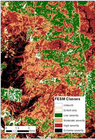
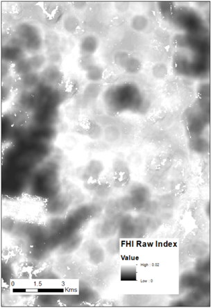
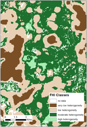
Figure 1 Comparison of FESM classes, the raw FHI index and the FHI classes for an area burnt in Kosciuszko National Park in 2019-20.
How is the FHI made?
The FHI is a measure of distance-to-patch-edge based on the well-established FESM data to isolate the high and extreme severity class areas (full canopy scorch +/- canopy consumption).
The FHI quantifies the relationship between the proportion of high and extreme severity patch area and increasing internal distances to patch edge. The index ranges between 0 and 1, where smaller values describe a more homogenous landscape with fewer patches of larger sizes.
The FHI differentiates shapes and landscape configurations, not just the overall size of a patch. Rounder shapes or simpler patch edges have larger overall distances to high severity patch edges and with flatter FHI curves (smaller values) while elongated patches or patches with more complex edges and steeper FHI curves (larger values).
The method was originally developed by Collins et al. (2017) and has been modified for application on a sub-fire scale to generate continuous surface products.
How is the FHI used?
The data can be used to improve our understanding of the effects of high severity fire heterogeneity on the recovery and persistence of species, communities and ecosystems, and is suitable for monitoring and reporting.
This measure of fire heterogeneity is likely to have ecological relevance for ecosystems and regions wherever distance to patch edge may influence the post-fire recovery of species’ populations.
Recent applications of this data shows that extensive fires with little unburnt habitat resulted in larger plant and animal declines, and species exposed to homogenous high severity fire had decreased abundance or inhibited recovery (Driscoll et al 2024; Gibson et al. 2025). Furthermore, homogenous high severity followed by short interval fire may lead to greater risk of future homogenous fire (Gibson unpublished data).
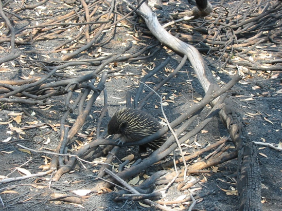
Photo Credit: Sean Thompson/DCCEEW. Echidna in Snowy Mountains.
The published paper contains more detailed information:
Data access
Fire heterogeneity index products (raw and classified) and a technical factsheet are available via the SEED portal.
References
Collins, B.M., Stevens, J.T., Miller, J.D., Stephens, S.L., Brown, P.M., & North, M.P. (2017). Alternative characterization of forest fire regimes: incorporating spatial patterns. Landscape Ecology, 32, 1543-1552
Driscoll, D.A., Macdonald, K.J., Gibson, R.K., Doherty, T.S., Nimmo, D.G., Nolan, R.H., Ritchie, E.G., & et al. (2024). Biodiversity impacts of the 2019-2020 Australian megafires. Nature, 635, 898-905
Gibson, R.K., Driscoll, D.A., Macdonald, K.J., Williamson, G.J., Nolan, R.H., Doherty, T.S. et al (2025) Remotely sensed fire heterogeneity and biomass recovery predicts empirical biodiversity responses, Global Ecology and Biogeography (TBC)
Linked Datasets
Remote sensing scientists from the NSW Department of Climate Change, Energy, the Environment and Wat...
Remote sensing scientists from the NSW Department of Climate Change, Energy, the Environment and Wat...