Remote Sensing of Fire
Remote sensing scientists from the Department of Climate Change, Energy, the Environment and Water’s, Science and Insights Division are developing a complete system of monitoring and mapping fire by remote sensing.
Information about the extent and severity of fire on a landscape is critical to understanding the relationship between fuels, fire behaviour and landscapes. Information about landscape patterns of fire heterogeneity can be used to improve our understanding of the effects on the recovery and persistence of species, communities and ecosystems. Monitoring post-fire biomass recovery at the landscape scale is important to help us understand drivers of recovery processes, identify vulnerable ecosystems and prioritise management interventions to support ecological resilience.

Fire extent and severity mapping (FESM) has been our major priority to date. However, progress is continually being made across all components of remote sensing of fire.
Fire Extent and Severity Mapping (FESM)
Using a combination of high-resolution satellite imagery and machine learning, remote sensing scientists at DCCEEW routinely map the severity of fires in NSW, aiding partners in conservation and fire management.
Fire extent and severity mapping (FESM) uses satellite imagery and machine learning to deliver timely fire severity maps. These maps help us:
- classify and map fires
- understand relationships between fuels and fire behaviour
- interpret how a fire has changed the landscape
- support better land and fire management
- support on-ground actions and conservation planning.
Mapping method
Since 2018, we have researched and developed a rigorous remote sensing approach to mapping fire extent and severity.
An early operational system was deployed in December 2019 to provide rapid-response severity mapping to support the department's operations during the emerging black summer bushfire crisis.
The refined operational system was launched in July 2020 and:
- links with the Rural Fire Service IT infrastructure
- largely automates the processing of fires
- delivers mapping in near-real time.
Our scientists are leading the continued refinement and further development of fire extent and severity mapping. The program will benefit from ongoing field validation and additional training data.
The published method papers contain more detailed information:
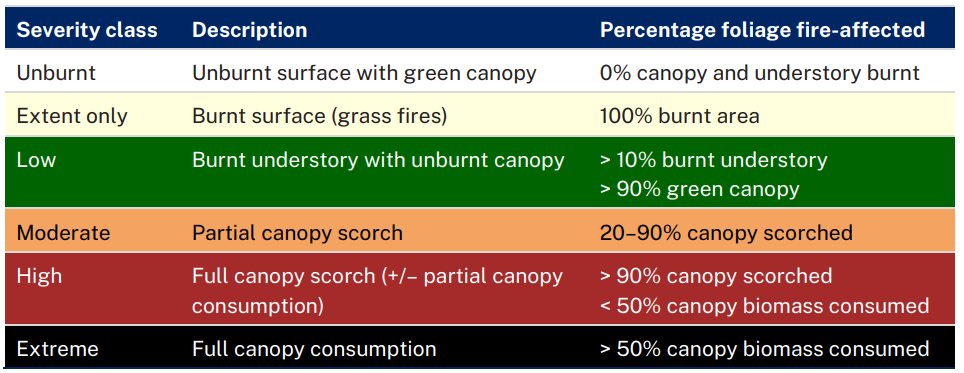
Fire severity classes
The FESM system uses a standardised fire severity classification to compare different fires across the landscape. The severity classes represent ecologically meaningful definitions based on levels of canopy scorch and consumption (see Table 1).
Table 1: FESM fire severity classification
Acknowledgements
This work has been led by scientists from the department and reflects extensive collaboration with the NSW Rural Fire Service, NSW National Parks and Wildlife Service, the NSW Bushfire and Natural Hazards Research Centre and other collaborators over several years of research, development and testing.